The Application Of Remote Sensing And Geographic Information System (Gis) For Monitoring Deforestation In South-West Nigeria
Keywords:
Deforestation, Forest, Vegetation, GIS, Remote sensingAbstract
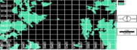
The forest vegetation of South-West Nigeria has been seriously undergoing deforestation in a rapid state. The region, with population of over 40 million, who engaged in cultivation of food crops and timber extraction for industrial uses have put the forest vegetation in the region under pressure. The need for monitoring forest vegetation changes therefore, becomes inevitable. Spot XS land use and vegetation cover map of and lansat MSS land use/vegetation map of 1995, a period of 17 years. Ilwis 3.1, Arcview 3.0 and Idrisi 32 were used for map capturing, digital mapping and image classification/analysis respectively. The study revealed that the forest vegetation which 3360.79Km2 in 1978 has reduce to 2549.659km2 in 1995. This means that 2367.67km2 of the forest vegetation remains as forest vegetation in 1995, while 1190.36km2 have changed to the land use types within the period. It was also revealed that forest vegetation was mainly due to urbanization, which results to settlement expansion, disturbed forest, grassland encroachment, reservoirs for the water sources and intensive agriculture. Enactment and operation of land use activities, control of indiscriminate bush burning and other protective measures were suggested for sustainable utilization of the forest vegetation.
References
Forestry Monitoring and Evaluation Unit (FORMECU) Abuja. SPOT XS
Guppy, V. (1984). Remote Sensing Imagery for National Resource monitoring. New York: Columbian University Press.
IIoeje, N. P. (1999). A new Geography of Nigeria. Benin: Longman Press.
Jones, D. (2000). Environmental Sustainability. London: Cambridge University Press, 290-300pp
Pickering, U. and Owen, G. (1997). Impact of Deforstation on Environment. New York: Herper and Row Publications
Pudis, K. (1983). Forest Control in Tropical Africa. Hulma Int. Pp 678-689 Rhett, B. (2005). Environmental Profile International Journal vol. II Pp 79.
Wood, J. (1999). Human Dimension of deforestation and Regrowth in the Brazil: from the Basis Science and remote sensing initiatives (BSRSI)