Land Use Changes In The Adjoining Rural Land Of Maiduguri Between 1961- 2002: Trends And Implications In Environmental Management In Borno State, Nigeria
Keywords:
Land use, Change, Remote sensing, GIS, MaiduguriAbstract
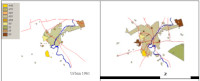
This study aimed at examining the trends in land use changes in Maiduguri urban area between 1961 and 2002 and the implications of these in environmental management. These were based on the use of GIS and Remote sensing techniques. Remote sensing data that were made available for this study include black and white aerial photographs of 1961 and 1972 at scale of 1:10,000 and 1:25,000 respectively and SPOT (panchromatic) at a scale of 1:40,000 with 10m resolution. These were interpreted to generate the land use maps for 1961 and 1972, and 1990. The land use map for 1990 on which the field observation of land use changes between 1990 and 2002 was used as the base data. The four land use maps were then digitalized and analyzed in a GIS environment using ILWIS 3.0 and ARCINFO 3.8. The total land area delimited in the study area within which changes were monitored over the period was 13,389 hectares. The study revealed among others that the land use changes trend in the city showed that Maiduguri grew at a fast rate. Consequently, it was concluded that such a high growth in a semi-arid environment where water supply is grossly inadequate, poses a lot of challenges in urban management. Therefore, there is a need to put in place procedures for regular acquisition of remotely sensed data that will make it possible to track the changes happening to land in the urban areas in Nigeria.
References
Adeniyi, P. O. and Amojola, A. (1999). Landuse/Land cover change Evaluation in Sokoto River Basin of NW Nigeria, based on Archival Remote sensing and GIS techniques. In Adeniyi, P. O. (ed.) Geoinformation Technology Application for Resources and environmental Management in Africa. African Association of Remote Sensing of the Environment, (AARSE) Unilag, Nigeria.
Adesina, F. A. and Amamoo, O. E. (1994). The potential of SPOT satellite Multispectral Imageries for land cover characteristic in tropical forest: A study from South Western Nigeria. Ife Research Publications in Geography, 4, 71-81.
Akorede, V. E. and Muhammad, Aji Y. (2001). Environmentally induced deprivations and the economic initiatives of the people of Maiduguri Nigeria. Ife Social Science Review Journal of the Faculty of Social Sciences, 19 (1), 330 - 344.
Areola, O. (1978). An introduction to aerial photo- introduction in Africa's contest. Ibadan: Nigeria Publisher Limited.
Briasoulis, H. (2001). Analysis of landuse change: Theoretical and modeling approaches. Unpublished Ph.D. Thesis submitted to the Department of Geography, University of Aesgean Lessees, and Greece.
Clark, D. (1996). Urban World/Global City. London: Routledge p.37
Dami, A. (2002). An assessment of land use changes in Maiduguri region between 1961-2002. Unpublished thesis submitted to the Department of Geography, Obafemi Awolowo University, Ile-Ife.
Dami, A. (2008). Geographic Information System based predictive study of environmental change in the Nigeria's section of the Chad Basin. Unpublished Ph.D Desertation submitted to the Department of Geography, Obafemi Awolowo University, Ile-Ife
FORMECU (1996). The assessment of land use changes in Nigeria between 1978-1993/1995. Geomatic International Inc.
Gulgler, J. (1997). Cities in the developing World: Issues, theory and policy. Oxford: Oxford University Press.
Kates R. W., Turner B. L. J, and Clark W. C. (1990). The great transformation. In Turner, B. L. II, Clark, W. C. Kates, R. W., Richard, J. E., Mathews, J. T. and Meyer, W. B. (eds.) Earth as transformed by human action (pp1-17) Cambridge: Cambridge University Press.
Lonergan, S. (1988). The role of environmental degradation in population displacement. Research Report 1, Global Environmental Change and Human Security Project. International Human Dimensions Program on Global Environmental Change.
LUC (1998). Proceedings, data gathering and compilation workshop (IBGP/IHDP). Land use and cover change
LUC (1999) Land use and cover: Implementation strategy. IGBP report 48. IHDP report 10, Stockholm: IGBP
Meyer, W. B. and Turner, B. L (1996). Change in landuse and land cover change: Challenges for geographers. Geojournal 39 (3), 237 - 240.
National Population Commission (NPC) (1991 and 2006). Population Census. Abuja: National Population Commission.
Odeyemi, Y. A. (1999). Landuse inventory and change detection in the urban - Rural fringes of Ilesa Area. Unpublished M.sc. Dissertation submitted to the Department of Geography, Obafemi Awolowo University, Ile-Ife.
Salami, A. T. (1995). Structural changes in Vegetal Cover in Ife and Ede Regions of Southwestern Nigeria between 1963 and 1993. Unpublished Ph.D. Dissertation submitted to the Geography Department, Obafemi Awolowo University Ile-Ife.
Tappan G. G., Sall M., Wood E. C. and Cushing M. (2002). Monitoring landuse/landcover trends in West Africa. A collaborative Programme of the UNESCO EROS Data Centre. June 2002. 60pp.
Tappan G. G., Sall M., Wood E. C. and Cushing M. (2004). Ecoregions and landcover trends in Senegal. Journal of Arid Environment, 59, 427-462
Turner, B. L. II. and Meyer, B. L. (1994). Global landuse and land cover change: An overview. In Meyer, W.B. and Turner, B.L.II. (eds.) Changes in landuse and land cover: A global perspective. Cambridge: Cambridge University Press. pp. 3-10.
Turner B.L. II., Skill D., Sanders S., Fischer G., Fresco L., and Lemmas R. (1995). Landuse and land cover change. Science/Research Plan. IGBP Report No. 35, HDP Report No. 7 IGBP and HDP Stockholm and Geneva. pp.8-16
Yemefack, M. (2005). Modelling and monitoring soil and land use dynamics within shifting agricultural landscape mosaic systems in Southern Cameroon. PhD Desertation. ITC Desertation 121. ITC, Enschede and Untrecht University, The Netherlands.194pp
Yuliang Q., Ying W. and Junyou T. (2004). Study of remote sensing monitoring of dynamics change of the Loess Plateau forest resources Advances in Space Research 33,pp 302-306
Warren P. L., Knapp P. A., Parton M. C., Schowenerdt R. A. (1991). Monitoring arid land vegetation changes with Remote sensing: An example from southern Arizona University of Arizona Tueson, Arizona, U.S.A. pp.125- 135